Home
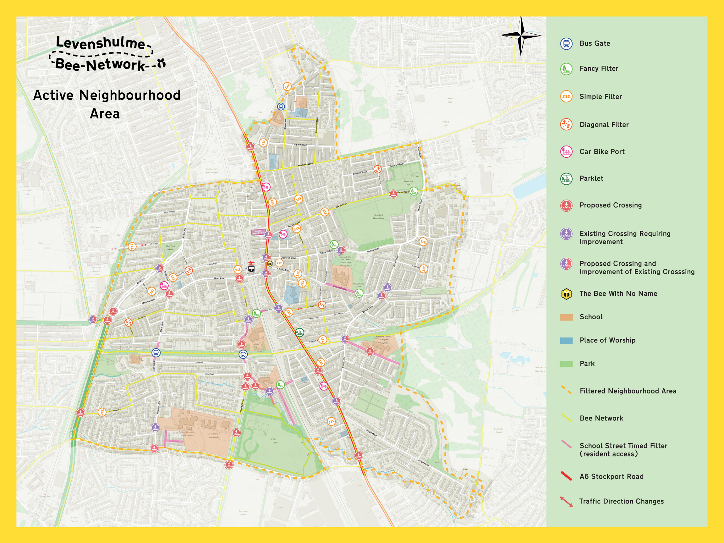
Our Active Neighbourhood Vision Map
Our Active Neighbourhood Vision Map
In March 2019, advocates from the Levenshulme Bee Network, along with Manchester City Council, secured funding to develop and install an ‘Active Neighbourhood’ for the community of Levenshulme.
We did this by engaging with Levenshulme residents at every stage. For the past year we have been co-designing the active neighbourhood with people across Levenshulme and this is the result.
It's the product of more than 4,000 comments on Commonplace, postal surveys to 9000 households and 40 separate co-design events, pop-ups, meetings and workshops we've been running.
The next stage is to begin the live trial of the modal filters. This will give people a chance to comment and tweak the locations of the filters to work most efficiently.
Our Active Neighbourhood Vision Map
This is the first version of our vision map developed and co-designed with the community, Sustrans and Manchester City Council. The map details all the current measures that we would like to deliver for ‘Our Active Neighbourhood’.
The proposals in this first vision map include: A filtered neighbourhood which will consist of the first 29 modal filters. These will be made up of the simple filters and fancy filters shown on the plan.
The other permanent features of the scheme shown on this version of the map will be developed over the next year and include:
● Proposed new crossings ● Proposed existing crossings requiring improvements ● Proposed School Streets ● Car Bike Ports ● A6 Parklet
Here's a timeline

The Trial Approach and Having Your SayEdit: Manchester City Council Trial Update
In the next few weeks we will be installing 29 temporary modal filters throughout the neighbourhood.
The trial will be undertaken using an experimental traffic regulation order which means that we can make changes following your feedback and monitor the impact for the first 6 months before the Council decides if the filters will be implemented on a permanent basis. All feedback from residents and monitoring of traffic, pedestrian and cycling levels as well as air quality levels will be considered before any of the filters are installed permanently.
The formal consultation will start once the trial is in place and there will be various ways to get in touch. All houses and business within the proposed active neighbourhood area will receive postal information about the scheme.
In addition, houses and businesses within 100m of a filter will have a chance to comment directly on the filters closest to their house.
What is a Modal Filter?
A modal filter prevents motor traffic from travelling along a residential street. You can still access all the addresses on the street, just not travel all the way along it by motor vehicle. They are a good way to stop vehicles from rat running and speeding through residential areas. Temporary modal filters are normally created using planters, bollards or any other barriers that stop some vehicles but allows walking and cycling.
Here’s a guide of the types of filters specific to our proposals:

What About Emergency Service Access?
Modal filters will be designed with the emergency services to make sure everything can be accessed.
Where Will They Be Positioned?
Modal filters work best when thought about within a ‘cell’ of streets and placed where they will be most effective at traffic calming. A cell is a network of residential roads that have outlying busy roads and then even busier main roads.
Our approach was to identify the cells with the community. We used local knowledge to map out the busy roads/busier roads and the smaller residential streets and designed the changes around these cells. The flow of traffic can be affected by the careful placement of one or two filters, cutting off through traffic for the whole area and pushing it out to the bigger roads.
It means that your street still forms part of the filtered neighbourhood even if it doesn’t have a modal filter directly on it.
Park Area MapsTo help you see the locations of the filters and make it easier to view and feedback we have used four local parks to identify the general areas.
We have also included the list of streets that have proposed modal filters on them as well as the types of proposed filters.
(At the bottom of this page there are PDF versions of the map areas to enable you to zoom in or print)These are:
Greenbank Park Area

Chapel Street Park Area

Cringle Park Area

West Point Gardens Area
 Crossings
The plan for new and improved crossings is based on your comments both online and at co-design events.
Manchester City Council highways team are now looking at the plan in detail and seeking to develop a prioritisation programme. We will be asking for more feedback on this as the plans develop. (The crossings presented on the plan for completeness of the current vision)
School Street ImprovementsSustrans have been working with six local primary schools on the proposed redesign at their school gates to enable safer and more active school street areas. The next stage is to develop these ideas together with the schools and MCC and the residents who live nearby.
We have outlined possible school streets road closures as part of the vision. A School Street is a time-limited road closure outside school during pick up and drop off times, allowing access to residents. These are highlighted in pink on the map.
The roads these are proposed for are:
Chapel Street Primary School - partial Chapel Street and Ratcliffe Street
St Andrew's Primary School - Broom Avenue
Alma Park Primary School - Alma Road
St Mary's Primary School - Errwood Crescent and Clare Road
St Andrew's Primary School - Broom Avenue
Cringle Brook Primary School - partial Slade Lane (section between Linden Park and Scarsbrick Road)
Acacias Primary School - Alexandra Drive and Roseleigh Avenue
We will present the detailed draft designs for each school soon and welcome your input. (The school street road closures are presented on the plan for completeness of the current vision).
Car Bike Port - Cycle Parking
As part of our 'quick wins' our project sought to install one car bike port on the A6 ( nearest Levenshulme Inspire). In response to your comments both online and at co-design events, we have identified an additional three locations for initial installation of more cycle parking where need was identified.
These will remove one parking bay space where there are parking bays or be placed on road where there is no parking bay. They will create up to eight cycle spaces each and create a strong visual impact and statement of intent about the 'active neighbourhood' in the chosen areas. Your feedback is welcome.
Locations are:
A6 Stockport Road ( nearest Levenshulme Inspire)
A6 Stockport Road ( Nearest Shine Hairdressers/Post Office)
Barlow Road ( nearest Madina Mosque)
Slade Lane (nearest Rex Laundrette/The Gherkin)
A6 Parklet
Another 'quick win' is the installation of a parklet which will reallocate two car parking bays for people, extending the pavement, greening the space and providing a space to sit, rest and park bikes. The location for the trial is identified as A6 Stockport Road nearest The Old Cop Shop/Antiques Village 'on the sunny side of the street'.
The community co-design session in October 2019 and subsequent feedback from Commonplace on the two design options has now produced a final design which we will showcase prior to installation in Summer alongside engaging local businesses about this trial. (The parklet is presented on the plan for completeness of the current vision).
Map Feedback
Finally, if you have any issues with understanding the current vision map or elements of the proposal, please let us know in the general comments space below. Your feedback can help us improve the accessibility of the map, written content and the project.
Additional materials

 Make sure your voice is heardAdd your email address
- 9% of comments on Commonplace are never published.
We verify that all responses are genuine before publishing. - We’ll send you an email to confirm your response.
- Your email address will never be shared publicly.
Read our privacy policy.